Facebook: Southern Kiwi Photography | Twitter: SoKiwiPhoto | Google+: Kaylene Fister | LinkedIn: Kaylene Fister
Showing posts with label New Zealand. Show all posts

Tuesday, February 5, 2013

The Power of an Image

Lots of people are raving over the Ram Trucks Super Bowl ad - and rightly so, because it is a good one.  Coming from New Zealand, where farming is a huge industry, I'm partial to this kind of imagery.  I didn't grow up on a farm but I'm from a small town and had friends that did live on farms.  I even managed to convince Mum to let me have a pet lamb one year, to go along with the rabbit, two cats and a dog.

Have another look at the commercial, this time with the sound off. The images are fantastic! They portray the gritty tenacity that makes a farmer successful. It's not just a career, it's a way of life and the photos on this video are a window into that life.

Think about this video when you next go out to have some fun with your camera.  Remember how it tells a story, even without the audio.  Try to accomplish the same with your photography - we're storytellers and images are our means to that end.


Friday, November 30, 2012

2013 Calendar - New Zealand


Some of you know that Steve and I went home to New Zealand earlier this year for my brother's wedding (yay!). While we were there we toured around the country a little, taking photos on the way. The result is this calendar with a selection of photos from our trip.

The calendar is on sale for US$15.00 if you place your order by 14 Dec 2012, after that it will be US$20.00.  Price does not include tax or shipping & handling.

Email me at kaylene.fister@southernkiwiphoto.com to place your order and include your name, phone number and quantity.

Visit my website for more information.


Tuesday, July 17, 2012

New Zealand - Fox Glacier

And we're back with images from New Zealand!  The last post in this series saw us leaving Franz Josef Glacier and now we're heading for Fox Glacier.  We saw four glaciers while were doing our South Island tour; the other two being at Milford Sound and Glenorchy, but Franz Josef and Fox were the ones we saw 'up close and personal'.

The trail to the foot of Fox Glacier is more strictly set out, with plenty of signs warning against straying from the path and instructing you to keep moving.  There's a good risk of rock fall so it's not a place to camp out for too long!

The photo below shows rock fall on the left.  Fox has much steeper valley walls than Franz Josef, giving you a better feeling of how ice carved a path to the sea.  To get a sense of scale, have a look at the people on the  path at the right side of the photo.


Storms roll in quickly around this part of the country and when they come up like this one is doing, you start to realise why trampers (hikers) run into trouble if they're not properly prepared.


Here's the river coming out of the bottom of Fox, with the same milky glacial water as we saw at Franz Josef.  Yup, those are chunks of ice - and they're not small - that's a huge boulder behind them.


And now we see Fox Glacier itself.  There are two groups of people in this photo; one near the middle of the frame, halfway between the river and the two rock chunks that stick out, and the other about a third of the way down from the top of the glacier.  They're pretty tiny so look hard!


Behind Fox is are more mountains - no snow at this time of year - which are shaded by the fast-moving black storm clouds.  Some rain drops started coming down and we decided it was time to head back to the car.  Even in summer, the temperature drops pretty quickly when the sun goes behind a cloud.

This will be the last of the New Zealand Series posts.  Please visit the Southern Kiwi Photography website for New Zealand photos - check back often to see images as I upload them!


Thursday, May 17, 2012

New Zealand - Saying Goodbye to Franz Josef Glacier

One thing about New Zealand weather is it's changeable nature.  The various mountain ranges cause a vast difference in weather patterns within a few kilometres.  These two photos below are a good example.  The first is taken near the base of Franz Josef, looking west as the river winds its way out to the Tasman Sea.  You couldn't ask for prettier blue skies.

I don't much like that there are a bunch of tourists in my photo (just as I'm in theirs!), but they do give a sense of scale; showing the size of this flat, broad valley that is typical of one formed by a glacier.  Valleys caused by rivers are V-shaped.


Here we have one last look back at the glacier before taking the trail back to the carpark.  There was a bit of a storm brewing over the mountains, giving us the push needed to get back on our journey south. The stream in the foreground is from the waterfall you can see on the left of the photo above.  Notice that it's your standard, clear water and not the milky colour of the glacial river shown above.


Franz Josef used to fill the valley as far as the scrub line in this photo.  As you can see, it's receded quite considerably.  But before you go all 'global warming!' on me, the glacier has gone through several periods of growing and receding over the past 260-odd years.  

In 1750 it filled the valley well beyond where the river disappears around the corner in the top photo and over the next 150 years, it slowly shrank back to the scrub line.  From around 1910-1990 Franz Josef experienced a roughly 20 year cycle of advance and retreat.  In 2000 it advanced significantly, to about as far as you can see in the top photo.

I remember a time when you could put a stick in the ground at the base of the glacier at the start of the day  and by night the stick would be swallowed up in ice.  Franz Josef may be a shadow of his former glory, but he's well capable of marching his way back down the mountain.  He's done it before.


For more in the New Zealand series, click HERE

Friday, April 13, 2012

New Zealand - Glacier Melt

Leading out from the base of Franz Josef Glacier is an ice-melt river.  The water colour is like nothing I've ever seen in a waterway; it was a grayish milk.  In places you can see chunks of ice - that water is cold!  At the start it is a small stream, but as it runs a path to the sea, it merges with waterfalls and other glacier melt rivers.  This photo is taken at the very foot of Franz Josef.  Pressure and friction cause the bottom of the glacier to heat up, melting some of the ice and forming the start of the river.


Here below is a photo I took with a faster shutter speed so you can see exactly how the actual river looks.  This is not a black & white photo - it's full colour!


For more in the New Zealand series, click HERE

Thursday, April 12, 2012

New Zealand - Franz Josef Glacier

From subtropical to glacial - New Zealand has it all.  Roughly halfway down the west coast of the South Island is Franz Josef Glacier.  An easy and pretty 30 minute hike takes you to the foot of the glacier, which pushes its way out of the majestic Southern Alps range.


The immense scale of the glacier (of which we only see the very bottom) is not apparent even when standing at the base looking up.  It's only when you spot a group of people taking a guided tour onto the glacier that you realise how big it is.  Do you see them?  The first group is in the middle of the lower section of ice (roughly where the lower right Rule of Thirds lines cross) and the second, smaller group is further down, to the right.

Below we have a close up of the glacier.  The ice has cracked and formed crevasses under the immense pressure from further up.  What surprised me most was how astonishingly blue the ice is.


For more in the New Zealand series, click HERE


Tuesday, April 10, 2012

New Zealand - West Coast Streams and Waterfalls

A lot of rain makes for beautiful rainforests and an abundance of streams, rivers and waterfalls.  The trail out to Franz Josef Glacier leads through native bush and alongside waterways such as this one below.


For more in the New Zealand series, click HERE

Monday, April 9, 2012

New Zealand - Sailing Cook Strait

New Zealand is made up of three main islands: the aptly-named North Island and South Island, and the much smaller (but not forgotten) Stewart Island.  Between the North and South Islands flows Cook Strait, connecting the Tasman Sea from the west and the Pacific Ocean to the east.

At its narrowest point, Cook Strait is only 24km (14.9mi) wide, however the trip between Wellington and Picton is 70km (43.5mi).  The southern leg of this three hour ferry ride is a visual treat through the scenic Marlborough Sounds.


For more in the New Zealand series, click HERE

Monday, April 2, 2012

New Zealand - Rainforest

Say the word 'rainforest' and most likely the kind of places that come to mind are the Amazon and Hawaii.  However, rainforests are not restricted to hot, humid regions.  The US northwest has rainforests and a great deal of New Zealand is covered in rainforest.

The thing about rainforests is that they need a lot of water - hence the name rain-forest.  So it wasn't surprising that we met with rain on the west coast of the South Island.  Lake Ianthe, roughly halfway between Hokitika and Franz Josef Glacier, is a pretty area with plenty of typical New Zealand bush, as shown in these photos:


For more in the New Zealand series, click HERE


Wednesday, March 28, 2012

New Zealand - Punakaiki: Pancake Rocks

The Pancake Rocks at Punakaiki really are a spectacular sight.  The layers were caused by dead marine creatures settling on the seabed 2km (1.25mi) below the ocean surface, along with with mud and clay.  The weight of the water gradually compressed the sediment into hard lime-rich layers and softer mud layers.  

This layering and compressing continued, and the formations were eventually raised above sea level by earthquake activity over a great period of time.  Once exposed, wind, rain and waves eroded the soft layers, leaving the aptly-named pancake stacks.


This shot was taken at the other end of the bay from the Pancake Rocks trail.  The sun peeked through clouds and lit up the cliff face, giving a better idea of the size of the formations.


For more in the New Zealand series, click HERE


Tuesday, March 27, 2012

New Zealand Weka

Our second day in the South Island saw us heading from St. Arnaud to Westport, hoping to get photos of seals at Cape Foulwind.  Unfortunately it was raining and blowing a gale (go figure) but I was treated with a weka which allowed me to get quite close.  These birds are around 55cm (22in) in length and are one of the many flightless birds native to New Zealand.


For more in the New Zealand series, click HERE


Monday, March 26, 2012

New Zealand Pukeko

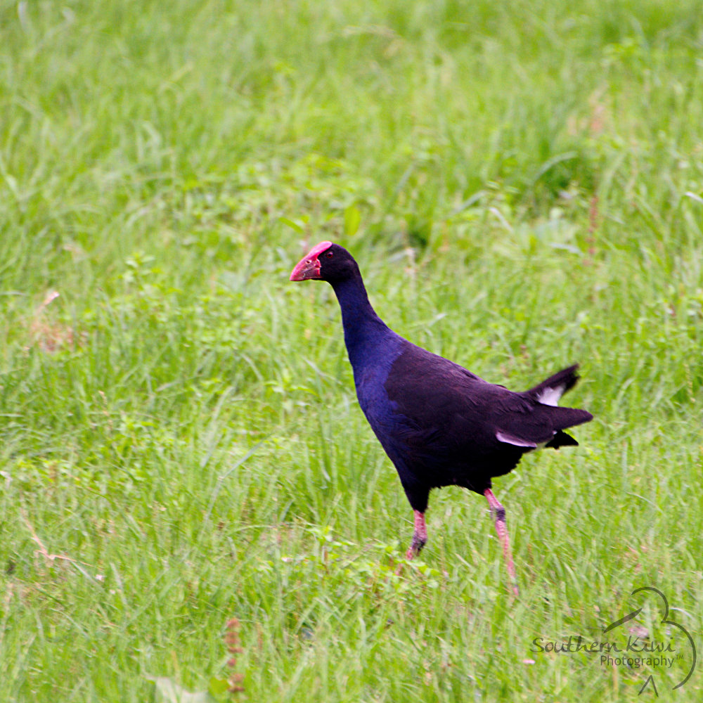
It's fairly well-known that New Zealand has some unique and, well, downright odd-looking birds.  Not least of which is the pukeko.  Standing at around 50cm (19in) high, they can be spotted in paddocks and along the roadside pretty much throughout the country.

This guy below was in a less-travelled area and was not all that keen on my interrupting his breakfast.  The white feathers you can see under his tail are flashed to other pukeko as a warning of danger.


For more in the New Zealand series, click HERE

Thursday, March 22, 2012

New Zealand Fur Seals

Apparently it's International Day of the Seal today in the USA.  So in honour of that, here are some photos of the New Zealand Fur Seal.  Enjoy!


This little guy above was a little nervous about how close I was getting.  But not to worry - mum (below) has an eye on things.  Taken north of Kaiapoi, on the east coast of the South Island.


A likely bunch!  After having sunned themselves silly, these nine seals decided to pass out in the shade.  Taken in spectacular Milford Sound, west coast of the South Island.


For more in the New Zealand series, click HERE

Wednesday, March 21, 2012

New Zealand - Huka Falls, Taupo

Lake Taupo is the largest lake in New Zealand, located in the middle of the North Island.  The outflow of Lake Taupo is the beautiful Waikato River, which flows north and powers much of the North Island with nine hydro-electric power stations along it course.  Starting before Lake Taupo, the Waikato flows through it and continues for another 425km (264mi) to the Tasman Sea, south of Auckland at Port Waikato.

After exiting Lake Taupo, the Waikato River narrows from around 100m (328ft) to only 15m (49ft) wide, forming the Huka Falls.  Running for 8m (26ft) and ending in an 11m (36ft) drop, it is not a particularly tall waterfall, however the appeal it has is the sheer volume of water that forces its way through this small channel.   At 220,000 litres (7,769cu ft) per second, the water is irrepressible and continually wears at the hard granite rock, undercutting the canyon below the waterline.

This first shot is taken from a footbridge which spans the channel about halfway along the Falls, allowing visitors to view them from both sides.  The concrete and steel bridge vibrates continually, giving you an idea of the power of the water as it pounds against the canyon's granite sides.


Notice the colour of the water after the first little drop.  The brilliant turquoise is clearly seen for the length of the Falls, ending in a spectacularly vibrant display in the turbulent pool at their base.

The photo below shows the final 11m drop, which is formed by a 6m (19ft) cliff in the granite bed.  The full height of the waterfall is due to the volume of water, which roughly doubles the height.


For the first article in the New Zealand series, click HERE


Monday, March 19, 2012

New Zealand - There's No Place Like Home

Two a.m. this morning saw me straggling in after a fabulous trip home to New Zealand with my wonderful husband.  We spent three weeks in paradise: 10 days on a whirlwind tour of the South Island and the remainder with family in my hometown region of Hawke's Bay.

We had a blast and it was well worth the plane-swollen ankles and jet lag.  Waking this morning, however, it seemed like a dream and I wondered if it had really happened.  Not to worry - I have the photos to prove it!

I'm going to run a series of posts documenting our trip to Godzone and to kick things off, here's a sneak peek of what's to come: